City of Riverside Innovation Corridor
Overview
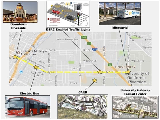
The City of Riverside Innovation Corridor is a strategically defined 10‐km (approximately six-mile) segment of University Avenue linking the University of California, Riverside (UCR) campus with downtown Riverside. This corridor was specifically selected for its proximity to expanding transit and alternative transportation networks, research institutions, and urban amenities, making it an ideal environment for innovative transportation and environmental technologies.
Strategic Testbed for Future Mobility and Sustainability
-
Geographic and Strategic Significance:
- A six-mile stretch of University Avenue between UCR and downtown Riverside, positioned at the nexus of transit networks, research hubs, and vibrant urban entertainment destinations.
-
Advanced Connectivity and Infrastructure:
- All traffic signal controllers are being upgraded to be compatible with SAE connectivity standards.
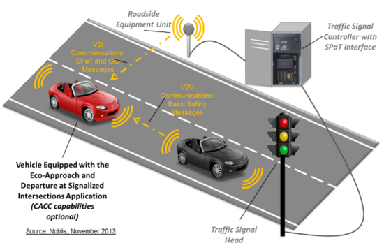
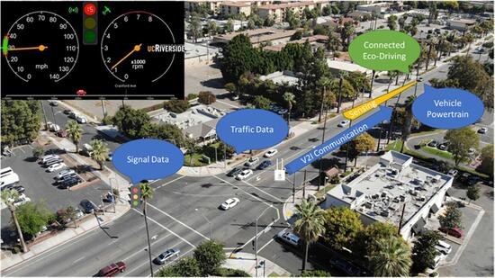
- Dedicated Short Range Communication (DSRC) roadside units are mounted at each intersection to broadcast real-time Signal Phase and Timing (SPaT) messages, alongside RTCM and mapping data that enable geofencing and accurate positioning.
-
Key Applications and Testbed Purpose:
- The corridor serves as a critical testbed for Connected and Automated Vehicle (CAV) applications, including eco-approach and departure (EAD), eco-transit operations, smart intersection management, and more.
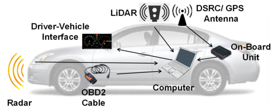
- In-vehicle Digital Visual Interfaces (DVIs) display signal status, countdown timers, and target speed recommendations to guide drivers in optimizing energy consumption and traffic flow.
-
Environmental and Sustainability Innovations:
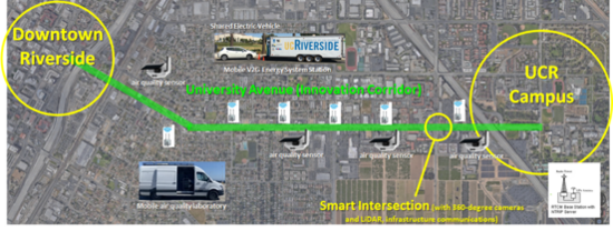
- New generation air quality sensors are planned for deployment at bus stops, intersections, and near freeway corridors to evaluate traffic-related air quality and public health impacts.
- Additional futuristic elements, such as shared zero-emissions mobility services, renewable energy generation, and vehicle-to-grid interactions, will further enhance the corridor's multi-disciplinary approach to sustainable urban mobility.
Key Technologies and Applications
-
Testbed Overview & Location
Key Vehicle Testbed Location:
- Geographic Setting:
- The testbed is located in Riverside, California, along a six-mile section of University Avenue between UCR Campus and Downtown Riverside.
- It comprises 10 instrumental intersections along a four-lane urban arterial.
- Infrastructure Characteristics:
- The arterial corridor is outfitted with upgraded traffic signal controllers that broadcast real-time signal phase and timing (SPaT) data.
- Video analytics and advanced sensing systems are deployed along the corridor for continuous monitoring and experimental data collection.
- The corridor is used for experimentation with shared, electric, connected, and automated vehicles—including cars, buses, and trucks.
- Geographic Setting:
-
Advanced Traffic Signal and Communication Systems
Modernized Signal Infrastructure:
Signal Controller Upgrades:
- All traffic signal controllers along the corridor are being retrofitted to broadcast SPaT messages.
- DSRC (Dedicated Short Range Communication) roadside units are mounted at each intersection to receive and transmit SPaT, RTCM, and map messages. These ensure accurate vehicle positioning and support geofencing functionalities.
Traffic Signal Information Systems (TSIS):
- A 4G/LTE cellular network relays real-time SPaT data from the signal controllers to a centralized TSIS server located at UCR.
- Vehicles equipped with onboard units can request and receive this SPaT data through the same cellular network.
- Currently, this system is actively used to test an Eco-Approach and Departure (EAD) application designed for heavy-duty trucks.
In-Vehicle Digital Visual Interface (DVI):
- Displays real-time signal phase status, countdown timers, and target speed recommendations to support energy-efficient driving behavior at intersections.
-
Connected Vehicle Applications
Eco-Approach and Departure (EAD):
-
Application Overview:
- Vehicles “listen” to upcoming signal phases, enabling drivers to adjust speeds for an energy-efficient approach to signalized intersections.
- The Digital Visual Interface provides drivers with recommended target speeds based on the current SPaT data.
-
Performance Outcomes:
- Mobility Improvements: Reduction in delays by 5% – 20%.
-
Energy Savings: Potential energy consumption reduction by 10% – 20%.
Eco-friendly Cooperative Traffic Optimization (ECoTOp):
- Technical Approach:
- Integrates connected vehicle trajectory management with adaptive signal timing.
- Research, including studies presented at the Transportation Research Board Annual Meeting (2023), supports this method as an effective means to optimize longitudinal vehicle dynamics while reducing emissions.
-
-
Simulation and Testing Platforms
Complementing Real-World Testing:
-
Simulation Capabilities:
- Advanced modeling platforms are employed to simulate the mobility and environmental benefits of widespread CAV adoption.
- These simulations validate experimental data and predict the system-wide impacts of integrating shared, electric, connected, and automated vehicle technologies.
-
Benefits:
- Provides critical insights into the projected benefits on traffic flow and emissions reduction.
- Supports continuous system optimization and integration of emerging technologies.
-
-
Environmental Monitoring and Sustainable Innovations
Integrated Air Quality and Energy Initiatives:
Air Quality Sensors:
- Next-generation air quality sensors are deployed at key locations—including bus stops, intersections, and near freeway corridors—to monitor emissions and assess public health impacts.
- Early results indicate smoother traffic flow and up to 15% reduction in emissions.
Sustainable Mobility and Energy Solutions:
- The corridor is also testing shared zero-emission mobility services, renewable energy generation, and vehicle-to-grid interactions.
- These initiatives complement transportation improvements with broader environmental benefits.
-
Partnerships and Collaborative Initiatives
Collaborative Framework:
- Key Stakeholders:
- City of Riverside, Toyota, Honda, UC-ITS, NCST, and Caltrans.
- Collaborative Programs:
- Partnerships extend to initiatives such as the EcoCAR program and various research projects that drive both technological innovation and environmental sustainability.
- Key Stakeholders:
-
Media, Visuals, and Further Information
- On-Site Visual Demonstrations:
- Photographic evidence from Eco-Approach and Departure tests shows the in-vehicle Digital Visual Interface (DVI) displaying signal phase, countdown information, and eco-driving guidance.
- Additional Resources:
- For further technical insights and demonstration of smart intersection technologies, please refer to our presentation materials and view our demonstration video on YouTube: Watch Video.
- On-Site Visual Demonstrations:
